

[ad_1]

This is a story of snow and blizzards as much as it is an ode to a very special tree.
In 2019 I section-hiked the Pacific Crest Trail (PCT) from Campo to Kearsarge. In 2023, I returned to thru hike the entire trail. Ultimately concluding my hike at an unorthodox monument that I walked to from both Mexico and Canada: a sequoia tree.
Both of my hikes started in Campo, and both ended in the Sierra, in my birth state. My northbound hike eventually turned southbound.
This living, sentient monument, with its roots and pinecones, sheltered my friend and I during a June blizzard in 2023. This is the tree that for me, held the convergence of Mexico and Canada, nestled in a quiet corner of the Sierra Nevada.
The Beginning: Heading North
I started my PCT thru hike in 2023 headed north, my anthem being Matthew And The Atlas’ “To the North.” I had every intention of maintaining continuous footsteps all the way to Canada. This was not something I ever doubted that I could do, despite the snow. Perhaps overconfidence.
2023 saw one of the largest snowpacks in California’s recorded history. I felt ready, stubborn even, and I grew tired of the fear mongering I encountered as I made my way north. I had some snow experience in the high snow year of 2019. Both were high snow years. 2023 was just the largest.
I would eventually enter the Sierra Nevada with the same friend I climbed San Jacinto with in April. The one who helped name me Blaze.
The Middle: A Snowy Sierra

As expected, the Sierras were challenging. My hiking partner and I would hike out each morning around 2-3am. We would hike until the snow became soft, and would stop around late morning or early afternoon.
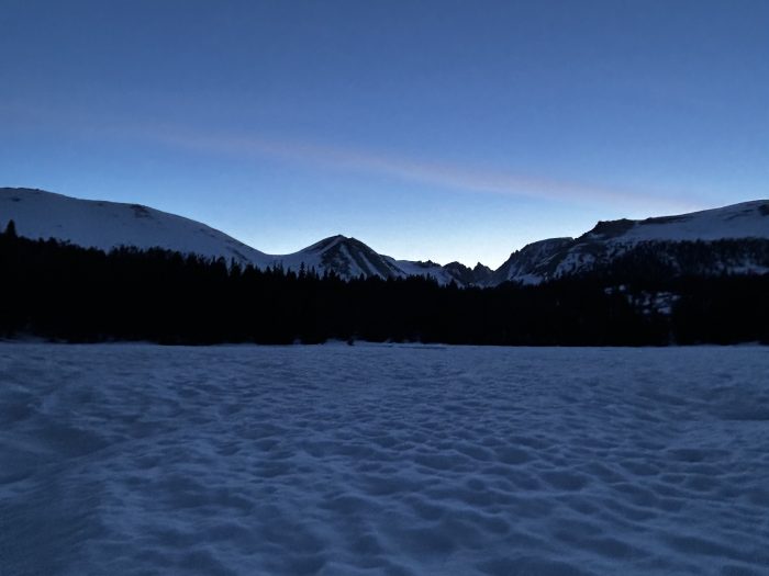
The mornings were cold and beautiful. Our visible breath and a universe of stars would greet us each day. A quiet knowing ran across the landscape; there was no sympathy for travelers across this snowy place.
With choice words, we would crunch our way atop the snowpack in the dark, headlights glowing. We’d veer off trail and down hills, across meadows, both of us trying to navigate using what little footsteps existed and yes, our GPS maps.
Our first rendezvous in the Sierra was interrupted when I concussed myself by slamming my head into a tree branch, cutting it slightly. I slammed my head into a low branch after going to the bathroom. Good thing I already had a trail name.
I wanted to hike on, but I was worried about my concussion and the high elevation. Our original plan was to hike another week or so to Bishop Pass. In my hesitation of forcing us off trail, my hiking partner helped me decide by emphasizing her desire to eat McDonald’s. Without her support, I’m not sure what I would have done.
Closed Highways and Concussions
In Lone Pine I visited the emergency room, where a doctor confirmed that I had a concussion (I was also roasted for being a smelly hiker). We’d hiked more than 26 miles that day, most of which were snow covered. Prior to reaching Lone Pine, we hiked straight down a closed highway. The high snow year had damaged the road, and it was under repair to mitigate rockslide risk.

I rested in Lone Pine for two days with my friend and her friend, all of us playing a made-up version of Uno using regular playing cards.
We received a hitch back up the steep highway, back to trail, from two kind road workers. They pointed out the areas along the highway which would need to be blown up with dynamite. This would ensure some parts of the mountain did not completely cave along the road.
The Tree
In early June, a couple of days into our return to trail, we hit bad weather. Snow in the Sierra is not unheard of in June, but the storm system was one of numerous historic weather patterns in California in 2023.
It snowed several inches of fresh snow throughout the day (over a foot above 11,000 feet). We pitched a tent to put on dry layers mid-day, and once the snow stopped we continued to camp. This is where we met my tree.
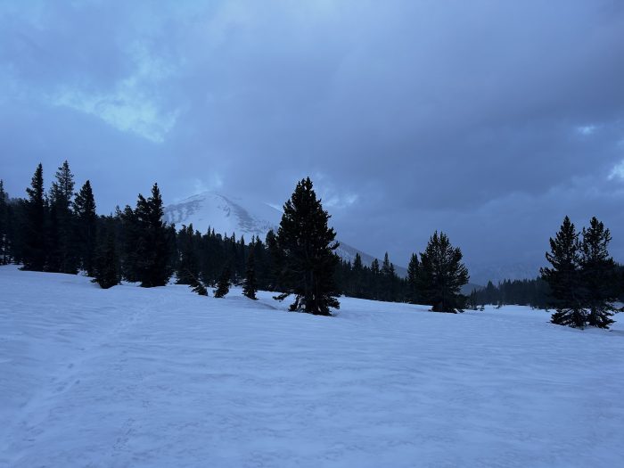
It was a chance meeting, if you will. My friend and I struggled to find a place to camp that afternoon, there were no large tree wells melted out. Before we planned to camp on the snow, my friend found the tree. The sequoia tree had a slanted area beneath it big enough for one tent.

My friend used her bear can lid to slightly level out the dirt, and we made a slanted spot flatter by moving some of the dirt over to one side. We camped there in my friends’ tent, beneath the sequoia tree.
I did not know it then, but the sequoia tree would change my life. Its roots and bark now woven into the rest of my life story.
On June Blizzards
Using my Garmin, I messaged two people off trail for a weather report. My Garmin reported sunny weather for the remainder of the week; a storm system had not been in the forecast.
About five days of storms were incoming. Multiple feet of snow were expected—on top of the foot already at elevations above 11,000 feet. High winds and lightning were also anticipated in the area just north of Whitney.
The condition of the snow from the first part of the storm concerned us. Bailing out Kearsarge and going over Forester Pass was a gamble, even if we found a window when the storm calmed. My friend—an avid snowboarder—cited her concerns regarding the stability of the snow.
Later that evening at camp we bumped into a few hikers headed back south, exiting via Cottonwood Pass. They had been camped on the approach to Kearsarge during the first part of the storm, and reported high winds and whiteout conditions. Based on this, and the upcoming few days of storms, we decided early the next morning that we too would bail via Cottonwood Pass. Going backwards, back to Lone Pine, but avoiding the steeper Forester Pass in the storm.
On Avalanches and Walking Back

The next morning at 3am, I took screenshots on FarOut of where we had camped. Something inside me knew that I was not immediately coming back, and that this tree was special and I would need to find it again. The tree was the furthest north we went that June. It was the point at which we turned around.
While walking the same miles southbound to our exit early in the morning, I took pictures of the mountains under starlight.
With the snow they felt wild, slightly ominous, and ancient. There was a quiet humming to the mountains here, energy in the rocks and trees. I already knew within my deeper self that I would return. Not in the way I’d planned, but in the way that was meaningful to me.
The storm worsened throughout the morning, eventually letting up, and then returning in the afternoon in fits and starts. It was clear that overnight more snow had fallen as we ascended higher up. The snow was sugary, pin wheeling, and unstable. It was slow going, but eventually we completed the 20+ miles to Cottonwood Pass. We made time by taking no breaks.
The steep pass normally has zig-zagging switchbacks, which was then fully covered in deep snow. Too steep to glissade properly (my hiking partner emphasized that she would not even snowboard it, being steeper than a double black diamond). We descended from the top of Cottonwood Pass straight down the steep slope in snow using our ice axes and moving backwards.

As a reminder that we made the right decision to exit early, two avalanches loudly boomed during our descent—like explosions. They sounded close, just over the ridge in a wide bowl we saw from the trail.
The End: Where Mexico and Canada Met
Once out of the Sierra, I decided not to return in June. The storm continued for another several days, and I could not wait it out that long. My grandmother was also passing away, and I wanted to see her for the last time. Another hiker gave me the idea to flip to Canada, as Washington had a low snow year.
The idea of becoming a southbounder, or SOBO, and flipping that many miles seemed insane. My entire brain was wired to hike north. That said, hiking south from Canada would mean that I could continuously walk back to the tree with no additional flips around the trail. It was a direct path back.
Even my grandmother liked the idea. In my goodbyes to her, she liked the idea that I was walking “backwards,” to the tree as she called it.
Words can’t quite explain what walking back to this tree from Canada meant. Close to the place where I ended in 2019, and back to the place where I turned around in earlier June 2023. To the place I would call my living monument.
Each day walking south was a quest. In my tired moments, moments struggling with what I dubbed the “Oregon blues,” I would remind myself that the Sierras were still waiting. This tree was calling.
I told other hikers about my tree. I was nervous I wouldn’t be able to find it again, I only had photos of our campsite and a screen shot of a stream mile marker on FarOut.
In September, on the first day of autumn, myself and another hiking partner approached the area of the tree. I anxiously went to look for the tree alone while my partner filtered water. I thought I could find it alone, just as I think I can do most things in life alone.
As I hiked away, my hiking partner called out, “is that your tree?!” I thought we still had another mile to go. I stopped to look at the tree he was pointing to, heart racing, and I immediately knew.
It was my tree. It was exactly my tree. I walked over to it, approaching it with reverence. There it was in the warm sunlight of September. The branch we hung wet clothes on, the flat area we dug out in the dirt remained. The snow was gone. The pine needles were visible, and the area where two hikers took refuge on a June afternoon was there.
I had walked back to the tree from Canada, meeting the exact point I previously walked to from Mexico.
I sobbed. Rivers of tears both happy and sad for what was both the end and the beginning of all things. Ending in this special spot that I thought about every day for months, a spot I had already been to, meant more than all of the continuous footsteps in the world. This tree, in my home state. A tree which knows the story of a couple of hikers, caught in a storm, so one of them came back.

We napped under the tree before continuing to Mt. Whitney and eventually, Cottonwood Pass. The branches swayed in the light breeze, it was warm. Inviting. I lay under the tree for a couple of hours, wanting to communicate nothing but love to it. And then we left.


I later wrote this entry on Instagram:
The End on the Fall Equinox: 2,655+ miles on the PCT (122 days of walking and about a month off for family) – ending at the tree I turned back at during a freak June storm system in California’s highest snow year on record, Mexico and Canada met at this sequoia. The little spot we dug out to sleep in still remained, and the cold snow replaced by glowing warm sunlight.
My northbound hike, turned southbound, ended in the High Sierra in the state I was born, having walked from both Mexico and Canada. This time, the sequoia awake, the flowers blooming, the mountains letting us pass unbothered. A quiet monument, a perfect end. This is my monument. And that’s a wrap on the PCT 2023.
May all of us come to love a special tree someday. This is just one tree, and this is my ode to it.

[ad_2]
Source link


